

An Intimate Portrait of America's Ocean State
Rhode Island
In a nation of vast expanses and sprawling landscapes, Rhode Island stands apart as a testament to the principle that great things come in small packages. It is the smallest state in the union (only about 48 miles long and 37 miles wide) yet within its modest borders lies a concentration of American history, culture, and natural beauty that rivals states many times its size.
This isn’t merely a state that happens to be small; it’s a place where intimacy breeds intensity, where every mile tells a story, and where the phrase “everyone knows everyone” isn’t just a saying, it’s practically a way of life.
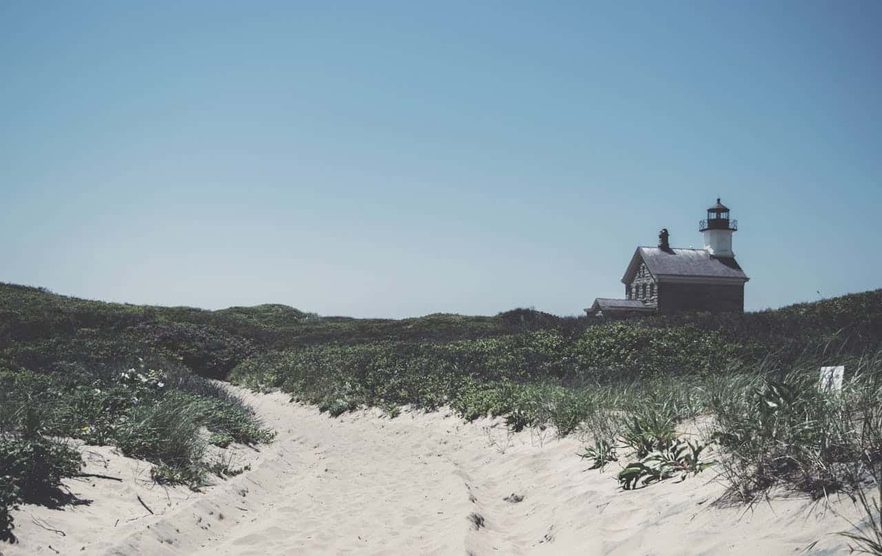
Table of Contents
- Geography & Natural Landscape
- Historical Timeline & Key Events
- Cultural Identity & Regional Character
- Economy & Industry Evolution
- Politics & Governance
- Cities, Towns & Population Centers
- Arts, Literature & Creative Heritage
- Food Culture & Regional Cuisine
- Route 1: The State’s Eastern Thread
- Share your Rhode Island route 1 memory
- Hidden Gems & Local Secrets
- Modern Challenges & Future Outlook
- Conclusion
Geography & Natural Landscape
The Ocean State’s Maritime Embrace
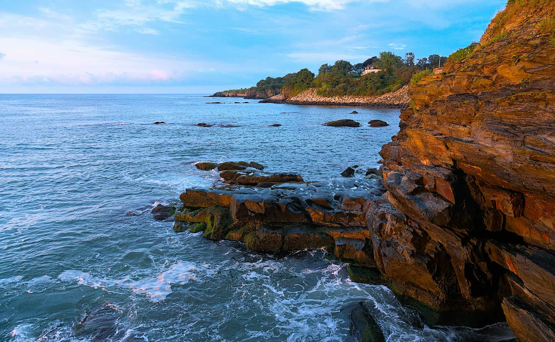
Narragansett Bay is a major feature of the state’s topography. There are more than 30 islands within the bay; the largest is Aquidneck Island, which holds the municipalities of Newport, Middletown, and Portsmouth. The second-largest island is Conanicut, and the third is Prudence.
This vast inland sea essentially splits Rhode Island in half, creating a geography that has shaped everything from colonial settlement patterns to modern-day commuting routes.
The state’s coastline stretches for 400 miles, a remarkable figure considering its compact size. This extensive shoreline is the result of Rhode Island’s deeply indented coast, with numerous coves, inlets, and peninsulas creating a fractal-like pattern that maximizes waterfront access. All residents of Rhode Island live within a 30-minute drive to the Atlantic Ocean or Narragansett Bay.
Two Natural Regions
The state consists of two natural regions, which include the Coastal Lowlands and the New England Uplands. The Coastal Lowlands spread from southern to eastern Rhode Island and include the islands in the Narragansett Bay and Block Island. Sandy beaches and lagoons characterize the area, becoming forested westward of the bay.
The western portion of the state tells a different story. The western two-thirds of Rhode Island is part of the New England Upland, with hills rising as high as 800 feet (240 metres) above sea level. Here, the landscape becomes more rugged, with lakes and ponds dotting the terrain. The state’s highest natural point is Jerimoth Hill, 812 feet (247 m) above sea level.
Climate and Natural Challenges
Rhode Island’s location makes it particularly vulnerable to Atlantic weather systems. Rhode Island is vulnerable to tropical storms and hurricanes due to its location in New England, catching the brunt of many storms that blow up the eastern seaboard. Hurricanes that have done significant damage in the state include the 1938 New England hurricane, Hurricane Carol (1954), Hurricane Donna (1960), and Hurricane Bob (1991).
Due to the relatively flat nature of Rhode Island’s seashore, the state is vulnerable to storm surge and coastal erosion, especially as sea levels rise. This ongoing challenge has shaped both development patterns and environmental policy throughout the state’s history.
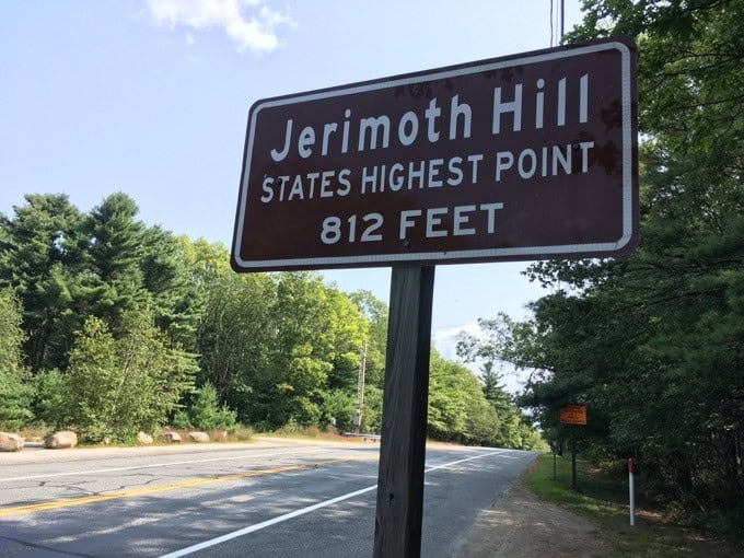
Jerimoth Hill marker
Historical Timeline & Key Events
Pre-Colonial and Early Settlement
Native Americans were present in southern New England by about 9500 bc. When European explorers and settlers arrived in the early 16th century, they found several Algonquian-speaking peoples inhabiting the region.
The Narragansett tribe dominated the area, controlling approximately two-thirds of what would become Rhode Island.
The pivotal moment in Rhode Island’s colonial history came in 1636. The Narragansett welcomed Roger Williams, a refugee from Massachusetts Bay Colony, and sold him the land to found Providence in 1636. Williams, a pioneer of religious liberty, believed in the separation of church and state and had been banished from Massachusetts for his beliefs. His settlement was the first place in America where government ruled “only in civil things,” and it attracted other dissenters.
The Charter and Colonial Development
The colony’s early years were marked by both internal divisions and external threats. Williams helped Anne Hutchinson and her followers, likewise exiled from Massachusetts, to purchase Aquidneck (later Rhode) Island, where they founded Pocasset (Portsmouth) in 1638. These early settlements were unstable and full of intensely religious individualists. In 1639 William Coddington and eight other prominent families left Portsmouth to found Newport on the southern end of Aquidneck Island.
In 1644, Providence, Portsmouth, and Newport united for their common independence as the Colony of Rhode Island and Providence Plantations, governed by an elected council and president. These four settlements were finally united into one colony by the Royal Charter of 1663.
Revolutionary Fervor
Rhode Island’s independent spirit manifested itself dramatically during the lead-up to the American Revolution. At approximately 2 a.m. on June 10, 1772, a band of Providence residents attacked the grounded revenue schooner HMS Gaspée, burning it to the waterline for enforcing unpopular trade regulations within Narragansett Bay.
On May 4, 1776, Rhode Island became the first colony to renounce allegiance to King George III of England.
However, in a characteristic display of Rhode Island contrariness, Rhode Island refused to participate in creating the U.S. Constitution and was the last of the original 13 states to ratify it.
Industrial Revolution Birthplace
In 1790, Samuel Slater, known as the Father of the American Industrial Revolution, established America’s first textile mill in Pawtucket.
This single development would transform not just Rhode Island but the entire nation, marking the beginning of America’s transition from an agricultural to an industrial economy.
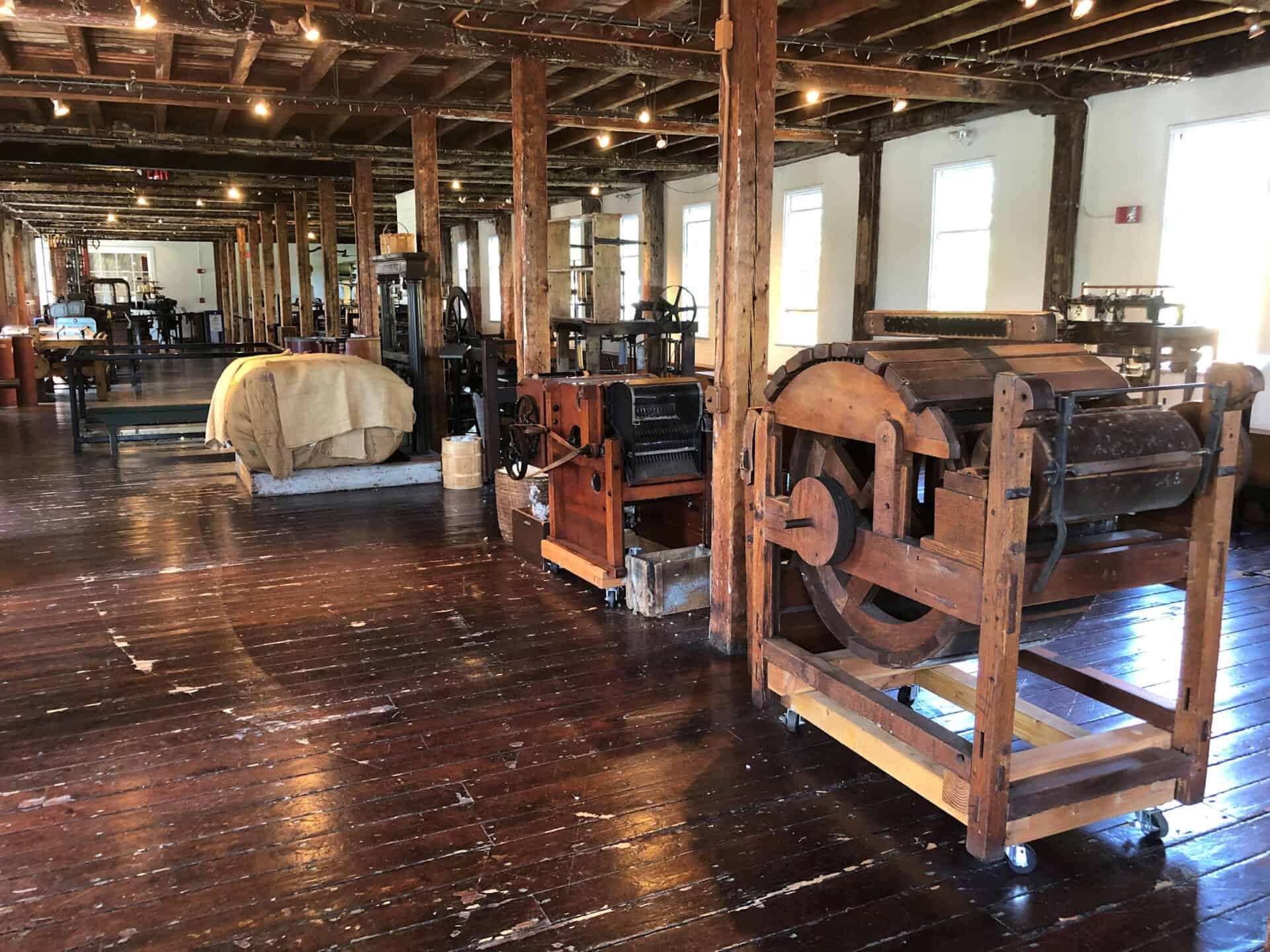
Slater Mill in Pawtucket, inside the cotton mill
Cultural Identity & Regional Character
A State of Fierce Independence
Rhode Island’s cultural DNA is encoded with independence, dissent, and a healthy skepticism of authority. Known for fierce independence and the absolute separation of church and state, Rhode Island attracted persecuted groups such as Jews and Quakers. Its government guaranteed freedom of religion for all its citizens and abolished witchcraft trials, imprisonment for debt, most capital punishment, and enslavement of both Black and White people, all by 1652.
This progressive streak continues to define the state. Rhode Island is one of the few states in America where everyone seems to known everybody. The entire population of one million maintains this sense of small-town familiarity, and the easy-going attitude is very infectious to visitors. Travelers can expect one of the warmest and friendliest welcomes in America when they visit Rhode Island.
The Coffee Milk State
Perhaps nothing captures Rhode Island’s unique cultural identity better than its official state drink: coffee milk. Coffee milk is officially the state drink of Rhode Island. And it is not just coffee mixed with milk. It is coffee syrup with milk, sold in cups and bottles. It was invented in the state around the 1930s.
The linguistic peculiarities of Rhode Island also set it apart. Many of the island’s population speak with a non-rhotic accent, meaning some of the letters in a word are not pronounced clearly. This is typical of people speaking English with an accent, such as those from New England, Great Britain and Australia. The accent is comparable to that of a Brooklyn accent or a cross between the Boston and New York accents, making butter sound like “butta” and water as “wata.” Rhode Island residents call drinking fountains as “bubblers” and pronounce coffee as “kaw-fee.”
Ethnic Diversity and Cultural Influences
Rhode Island’s relative isolation because of its natural maritime borders allowed the state to develop its very own culture. Its slightly over one million residents are composed of Italian, Irish, Portuguese, French, Dominican, Chinese, Guatemalan, French Canadian and Puerto Rican peoples.
This diversity manifests itself in the state’s cultural celebrations. Rhode Island’s diverse heritage comes alive in its numerous cultural festivals. A prime example is the annual Greek Festival, organized by the Assumption of the Virgin Mary Greek Orthodox Church. Over a three-day period, this festival immerses attendees in Greek culture, offering traditional cuisine, music, and performances.
Economy & Industry Evolution
From Textiles to Tourism
The story of Rhode Island’s economy is one of dramatic transformation. The nation’s first successful water-powered textile mill is located in Pawtucket, Rhode Island, which is considered the birthplace of the Industrial Revolution.
Throughout the 19th and early 20th centuries, textile manufacturing dominated the state’s economy.
The decline of Rhode Island’s textile industry was accompanied by that of many other manufacturers, notably those most closely associated with textiles. In most respects, Rhode Island suffered through an economic depression from the 1920s to the late ’50s.
However, by the 1920s, southern states’ strong competition for the cotton industry led to the decline of textile manufacturing, and the state began a transition to an economy dominated by service industries and tourism, due to the miles of beaches and pleasant weather.
The Jewelry Capital
The one manufacturing sector that bucked the general trend through most of the century was jewelry making, and Rhode Island was long dubbed the “jewelry capital of the world.” Until the late 20th century, the state produced much of the costume jewelry made in the United States, though global competition has since reduced this dominance.
Modern Economic Landscape
Today, The past few decades have seen a shift in the state’s economy from manufacturing to services.
Rhode Island’s $5.3 billion Ocean Economy and nearly 400 miles of coastline make the state an ideal location for emerging companies, especially those who specialize in the development of advanced materials and component boat/ship systems; ocean sciences and engineering; marine tourism; and the preservation of coastal communities and environments.
The state has also embraced its role as a tourist destination. Tourism is one of Rhode Island’s leading economic activities. Notable historical sites of the colonial and Industrial Revolution eras abound on the mainland.
Politics & Governance
A Democratic Stronghold
Since the Great Depression, Rhode Island politics have been dominated by the Rhode Island Democratic Party, and the state is considered part of the Democrats’ “Blue Wall.” Democrats have won all but four presidential elections since 1928, with the exceptions being 1952, 1956, 1972, and 1984.
The state has been reliably Democratic since 1928, only voting Republican four times – twice for Eisenhower in 1952 and 1956, for Nixon in 1972, and for Reagan in 1984, when he won every state except Minnesota.
This Democratic lean is particularly strong at the state level, where The Rhode Island General Assembly has continuously been under Democratic control since 1959.
Unique Governmental Structure
Rhode Island’s governmental organization reflects its small size and community-oriented nature. Rhode Island is divided into five counties but it has no county governments. The entire state is divided into 39 municipalities, which handle all local government affairs. There are 8 cities and 31 towns in Rhode Island.
Political Culture
The state’s political culture combines progressive social policies with a sometimes surprising fiscal conservatism. Since 1900, Rhode Island has voted Democratic 68.8% of the time and Republican 31.2% of the time. Since 2000, Rhode Island has voted Democratic 100% of the time and Republican 0% of the time.
This political consistency reflects a state where personal relationships often transcend party politics, where everyone really does seem to know everyone else, and where local issues can quickly become statewide concerns due to the state’s intimate scale.
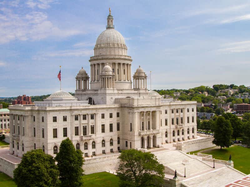
Rhode Island State House in Providence
Cities, Towns & Population Centers
Providence: The Creative Capital
The most populous cities in Rhode Island are Providence with 190,792, Warwick at 82,999, Cranston with 82,635, Pawtucket at 75,321, and East Providence with 46,900.
Providence dominates the state not just in population but in cultural and economic influence.
By the start of the 20th century, Providence hosted some of the largest manufacturing plants in the country, including Brown & Sharpe, Nicholson File, and Gorham Manufacturing Company. The city’s industries attracted many immigrants from Ireland, Germany, Sweden, England, Italy, Portugal, Cape Verde, and French Canada. These economic and demographic shifts caused social strife.
Today, As the largest city and capital of Rhode Island, Providence plays a prominent role in the state. With approximately 179,000 people, Providence sits in the northeastern part of the state at the tip of Narragansett Bay. The city’s downtown is a mix of historic buildings, modern skyscrapers, and a cultural district with restaurants, museums, and theaters. It also has many colleges and universities, including Brown and The Rhode Island School of Design (RISD).
Newport: Where Gilded Age Meets Colonial Charm
Newport is a seaside city on Aquidneck Island in Rhode Island, United States. It is known as a New England summer resort and is famous for its historic mansions and its rich sailing history. The city has a population of about 25,000 residents.
Newport hosted the first U.S. Open tournaments in both tennis and golf, as well as every challenge to the America’s Cup between 1930 and 1983. It is also the home of Salve Regina University and Naval Station Newport, which houses the United States Naval War College, the Naval Undersea Warfare Center, and an important Navy training center.
The Urban-Rural Dynamic
Despite its small size, Rhode Island maintains distinct urban and rural areas. The capital city of Rhode Island is Providence and it is also the largest city with a population of just 179,472. Rhode Island is the smallest state by land area with only 1,545 square miles and is 33.08% water. However, Rhode Island is the 2nd most densely populated state with more than 1,000 people per square mile.
The state’s development pattern follows its waterways. Major population centers today result from historical factors; development took place predominantly along the Blackstone, Seekonk, and Providence Rivers with the advent of the water-powered mill.
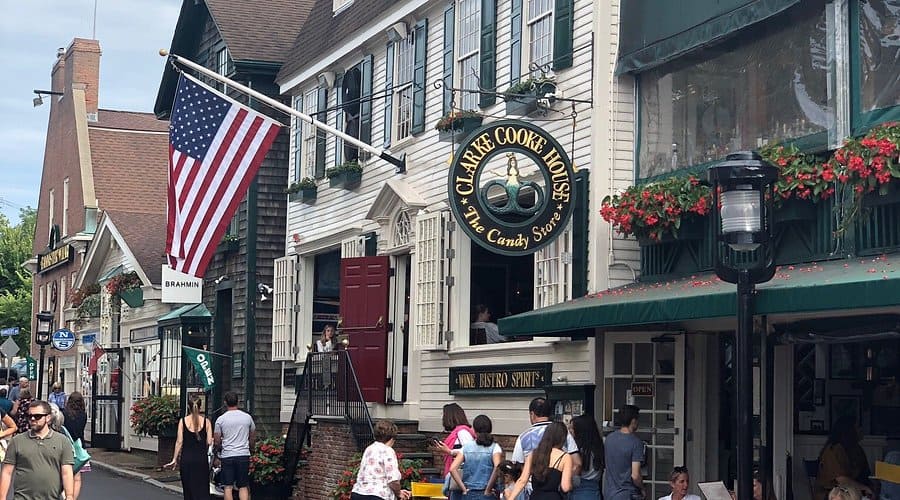
Newport’s historic waterfront or Thames Street
Arts, Literature & Creative Heritage
A Long Literary Tradition
Rhode Island has nurtured creativity since its founding. The Redwood Library and Athenaeum, in Newport, and the Providence Athenaeum, both proprietary libraries housed in architecturally important buildings, have roots dating to the mid-18th century.
The Providence Athenæum is the fourth oldest library in the United States, in addition to the Providence Public Library and the nine branches of the Providence Community Library. Edgar Allan Poe frequented the library, and met and courted Sarah Helen Whitman there. H. P. Lovecraft was also a regular patron.
Museums and Cultural Institutions
The Rhode Island School of Design Museum has notable collections, including early Rhode Island furniture and silver.
The Rhode Island School of Design Museum contains the 20th-largest collection in the United States.
The Rhode Island Historical Society operates the John Brown House Museum, a merchant’s mansion in Providence; built in 1786, the house is furnished with masterpieces of the Newport school of cabinetmakers and with other 18th-century antiques. The Museum of Work and Culture, in Woonsocket, also run by the society, is an interactive museum illustrating daily life in 19th-century Rhode Island mill towns.
The Newport Mansions
The Preservation Society of Newport County operates as museums several mansions that were formerly the summer homes of wealthy residents, including the Breakers, built by financier and philanthropist Cornelius Vanderbilt. Newport is the primary attraction for visitors, with its culture and the “summer cottages” which are, in reality, palatial seaside mansions of wealthy Gilded Age families.
Contemporary Arts Scene
The Rhode Island Philharmonic Orchestra, Opera Providence, the Rhode Island Civic Chorale and Orchestra, the Chorus of Westerly, and numerous smaller groups and organizations are among the state’s musical resources.
The capital, Providence, is known as the ‘creative capital’ for its extensive educational resources and arts community.
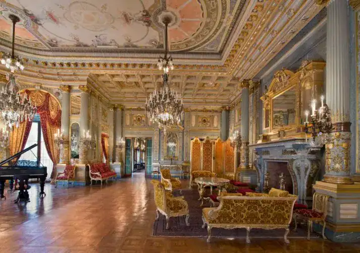
Interior of The Breakers mansion
Food Culture & Regional Cuisine
The Clam Cake: Rhode Island’s Signature Fritter
All Rhode Island clam shacks offer a certain dish that distinguishes them from similar seafood joints across New England. This is the clam cake, a kind of a seafood-studded cross between a beignet and a hushpuppy, and ideal for dunking in either clear Rhode Island-style or creamy New England clam chowder.
The savory clam cake fritters are doled out from take-out windows by the dozen or half-dozen, served in greasy paper bags or piping hot in a wax-paper lined basket, all year long. Their bread-like texture features a chewy interior enveloped by a thick and crunchy outer crust. The ingredients are simple: flour, water, baking powder, clam juice, and chopped or minced clams.
Coffee Milk: The Official State Drink
Rhode Island’s official state drink, coffee milk, is a delightful blend of milk and coffee syrup. Originating from Italian immigrants’ love for coffee in the early 20th century, this sweet, caffeinated treat has become a favorite.
The coffee syrup itself, which is sold by brands like Autocrat, basically a syrupy mixture of strong coffee and sugar. The food was initially created by the Italian immigrant population who lived in the state.
Del’s Lemonade: A Frozen Tradition
Dating back to 1948 in Cranston, Rhode Island, Del’s has expanded worldwide with some of the best tasting frozen lemonade on earth. Even with that global presence, Del’s will always be associated with Rhode Island.
Del’s Lemonade, a Rhode Island classic, is a slushy mix of lemons, sugar, and ice. This refreshing, tangy drink gained popularity quickly after debuting in Cranston, Rhode Island, in the late 1940s.
The Clear Chowder Controversy
Only in Rhode Island will you be able to eat the unique clear chowder, called the Rhode Island Clam Chowder, with tomatoes rather than milk.
This clear-broth version represents Rhode Island’s independent streak even in its cuisine, refusing to conform to either Manhattan’s tomato-based or New England’s cream-based chowder traditions.
Other Culinary Traditions
The quahog is a large local clam usually used in a chowder. It is also ground and mixed with stuffing or spicy minced sausage, and then baked in its shell to form a stuffie. Calamari (squid) is sliced into rings and fried as an appetizer in most Italian restaurants, typically served Sicilian-style with sliced banana peppers and marinara sauce on the side. (In 2014, calamari became the official state appetizer.) Clams Casino originated in Rhode Island, invented by Julius Keller, the maître d’ in the original Casino next to the seaside Towers in Narragansett.
Route 1: The State’s Eastern Thread
The Historic Post Road
Route 1 in Rhode Island represents more than just a highway, it’s a living timeline of American transportation history. At various points in time, every segment of Route 1A except the one in Westerly served as part of U.S. 1, which historically was the lower routing of the Boston Post Road mail route. The Route 1A designation came after the U.S. 1 designation was moved to a different alignment. This led to most segments of Route 1A being named Old Post Road or Post Road, while much of US 1 is now named the Commodore Perry Highway.
A Scenic Journey Through Coastal Communities
The smallest state in the Union, just 37 miles wide by 48 miles long, Rhode Island is nonetheless blessed with some 400 miles of coastline, counting its many coves, bays, and islands. Much of the coastline is lined with beaches that are open to the public. Driving U.S. 1 and U.S. 1A — with a side trip over to the resort town of Newport — is the best way to experience the coast, although short side trips are necessary to access many of the beaches and small coastal resort areas.
The route enters Rhode Island modestly. US 1 enters Rhode Island via a small bridge from Pawcatuck, Connecticut, to downtown Westerly. US 1 winds through downtown Westerly, passing two shopping plazas (the Granite Street Shopping Center and the Franklin Shopping Plaza) prior to a junction with Route 78, the two-lane highway designed to bypass downtown.
Share your Rhode Island route 1 memory
Do you have a story you would like to share? We want to hear it!
Create a View to tell a unique story about a specific place
Want to see what others wrote about Rhode Island?
Our Travel map has over 1400 posts from users like you
We have 2 types of content at Route1views:
- View: A unique experience at a single location
- Trip: A collection of experiences at different places, connected through a ‘road trip’
- Most first-time posters choose to make a View
A note about Route 1 Views
We are a user-driven social media site for celebrating and sharing stories along historic Route 1 USA. Using our platform is FREE forever and we don’t play any tricks. We don’t share your data or spam you with emails. We are all about sharing!

Connecting Beach Communities
As Route 1 progresses eastward, it serves as the main artery connecting Rhode Island’s famous beach communities. The first section of Route 1A is 8.1 miles (13.0 km) in length and runs entirely in Westerly. Beginning in downtown Westerly, the roadway takes a more southerly route for its first 3.7 miles (6.0 km) in the town, serving the affluent coastal community of Watch Hill and Misquamicut State Beach.
Through the Heart of South County
Farther south on 1A is Narragansett, a Victorian-era resort town located at the point where Narragansett Bay meets the Atlantic Ocean. Continue south from there to Point Judith, site of a historic lighthouse at the tip of a peninsula and several beautiful beaches, including Scarborough State Beach, which has a beachside boardwalk.
The roadway follows the historic Post Road from the intermittent residential and commercial areas of the northern section to the open space, agricultural land, marinas, and forested areas south of the Wakefield cutoff. Beginning as a web of Indian trails used for centuries by native inhabitants, the road was later developed in the colonial era to become an important route for carrying mail and newspapers.
Hidden Gems & Local Secrets
Beyond the Tourist Trail
While Newport’s mansions and Providence’s restaurants draw the crowds, Rhode Island’s true character reveals itself in its lesser-known corners. Block Island lies about 12 miles (19 km) off the southern coast of the mainland and separates Block Island Sound and the Atlantic Ocean proper.
This island remains one of the state’s best-kept secrets, accessible only by ferry or small plane, maintaining an unhurried pace that seems frozen in time.
The Blackstone River Valley
The river’s original Native American name was “Kittacuck,” which means “big tidal river.” The river’s present-day name originates from William Blackstone (originally William Blaxton) who landed in Weymouth, Massachusetts in 1623 and in 1625 became the first European immigrant to settled in what became Boston. Blackstone then resettled in Rhode Island in 1635, making his home along the river. The geography of the river and the valley it is located in gave rise to the American Industrial Revolution. An English immigrant by the name of Samuel Slater developed the first successful water powered cotton-spinning factory in the United States along the Blackstone River.
Secret Beaches and Coastal Access
The large number of beaches in Washington County lures many Rhode Islanders south for summer vacation. The state constitution protects shore access, including swimming and gathering of seaweed.
This constitutional protection means that many small beaches and coastal access points remain open to those willing to explore beyond the main tourist areas.
Historic Villages
Some of Rhode Island’s cities and towns are further partitioned into villages, in common with many other New England states. Notable villages include Kingston in the town of South Kingstown, which houses the University of Rhode Island; Wickford in the town of North Kingstown, the site of an annual international art festival; and Wakefield where the Town Hall is for the Town of South Kingstown.
Wickford is a pretty village dating from the early 1700s. Explore Main Street for a taste of the waterfront and the town’s colonial-era homes.
The Quiet Northwest
While most visitors gravitate toward the coast, Rhode Island’s northwestern corner offers a completely different experience. This rural area, part of the New England Upland, provides hiking trails, freshwater fishing, and apple orchards that burst into glory each fall. Small towns like Foster and Glocester maintain a rural New England character that seems worlds away from the busy coast, despite being less than an hour’s drive from Providence.
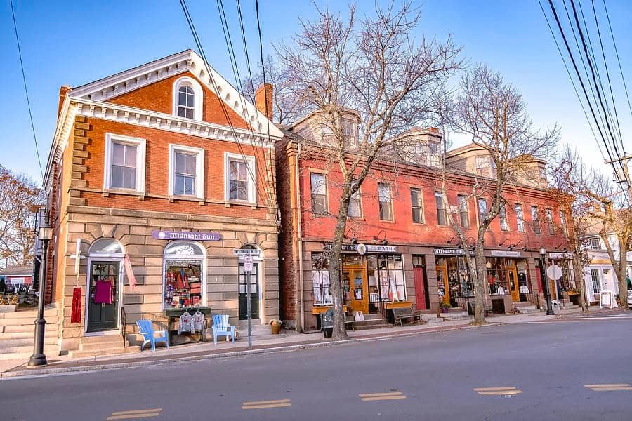
Wickford village waterfront
Modern Challenges & Future Outlook
Climate Change and Coastal Resilience
Rhode Island faces significant challenges from climate change, particularly given its extensive coastline and low-lying areas. On May 29, 2014, Governor Lincoln D. Chafee announced that Rhode Island was one of eight states to release a collaborative Action Plan to put 3.3 million zero-emission vehicles on its roads by 2025. The plan’s purpose is to reduce greenhouse gas and smog-causing emissions. The plan promotes zero-emissions vehicles and investments in the infrastructure to support them.
Rising sea levels pose an existential threat to many coastal communities. The state has begun implementing comprehensive coastal management strategies, but the challenge of protecting both natural resources and human infrastructure remains daunting.
Economic Transition
As Rhode Island was deindustrialized in the 20th century, the proportion of wage earners in manufacturing decreased from nearly three-fifths in 1900 to less than one-sixth by the early 21st century.This dramatic shift continues to shape the state’s economic landscape.
The state has worked to reinvent itself as a hub for healthcare, education, and marine-related industries. Rhode Island is an emerging leader in manufacturing innovation, with companies like General Electric, Electric Boat, Raytheon, and Textron. The state’s burgeoning maker movement is reshaping design and production methods.
Demographic Shifts
Rhode Island is home to an array of communities and cultures, including large immigrant populations. One in eight Rhode Islanders has migrated here from another country, with the most common nations of origin being the Dominican Republic, Guatemala, Portugal, Cabo Verde, and India. Providence, in particular, was recently ranked among the ten most ethnically diversified midsize cities in the United States.
This increasing diversity brings both opportunities and challenges as the state works to integrate new communities while maintaining its distinctive character.
Infrastructure and Transportation
The state’s small size, which has long been one of its defining characteristics, presents unique infrastructure challenges. With limited space for expansion and an aging transportation network, Rhode Island must find innovative solutions to move people and goods efficiently.
The Rhode Island Public Transit Authority (RIPTA) operates statewide intra- and intercity bus transport from its hubs at Kennedy Plaza in Providence, Pawtucket, and Newport. RIPTA bus routes serve 38 of Rhode Island’s 39 cities and towns. RIPTA operates 58 routes, including daytime trolley service (using trolley-style replica buses) in Providence and Newport.
Preserving Character While Embracing Change
Perhaps Rhode Island’s greatest challenge is maintaining its unique character while adapting to the 21st century. The state’s small size, which fosters its everyone-knows-everyone culture, also limits its options for growth and development. Balancing preservation of historic sites and natural areas with the need for economic development requires careful planning and community consensus.
The state’s future likely lies in leveraging its unique assets: its maritime heritage, educational institutions, cultural richness, and quality of life. As remote work becomes more common, Rhode Island’s combination of urban amenities, coastal beauty, and small-town charm positions it well to attract new residents seeking a different pace of life.
Conclusion
Rhode Island defies easy categorization. It’s simultaneously America’s smallest state and one of its most complex, a place where colonial history and cutting-edge innovation coexist on the same narrow streets. It’s a state where you can drive from urban Providence to rural Foster to the beaches of Narragansett in less than an hour, experiencing three different worlds along the way.
The Ocean State’s true magic lies not in any single attraction or characteristic, but in how all these elements combine in such a compact space. It’s in the way a Providence restaurant might serve traditional clam cakes with a modern twist, or how a centuries-old Newport mansion now houses contemporary art installations. It’s in the fierce pride residents take in their coffee milk and clear chowder, and in their stubborn insistence on doing things their own way, whether that means being first to declare independence or last to ratify the Constitution.
For travelers following Route 1 up the Eastern seaboard, Rhode Island offers something unique: the chance to experience an entire state intimately, to truly know a place rather than just pass through it. In an age of increasing homogenization, Rhode Island remains defiantly, wonderfully itself: proof that in America, as in life, the best things often do come in small packages.