US Route 1 enters Pennsylvania from Maryland at West Nottingham Township and runs northeast for roughly 100 miles through Chester County, Delaware County, Philadelphia, and Bucks County before crossing into New Jersey at Morrisville. It’s the shortest Route 1 state run on the East Coast by miles, but it passes through more American history per mile than almost any other stretch of the highway. The Brandywine Valley. Independence Hall. The Delaware River crossing at Washington Crossing. This is the corridor that made the country.
Where Route 1 Runs in Pennsylvania
The Route Through the Keystone State
Route 1 enters Pennsylvania from Maryland as a two-lane road through Chester County’s farmland and quickly widens into a four-lane divided highway. The Kennett-Oxford Bypass carries it northeast past mushroom farms and horse pastures before the road swings toward Longwood Gardens and the Brandywine Valley. From there it continues through the suburbs of Delaware County into Philadelphia, where it becomes Baltimore Pike and then runs through the city itself. North of Philadelphia, Route 1 passes through Bucks County along the Delaware River, hitting Washington Crossing before it exits into New Jersey at Morrisville.
The terrain is not dramatic by Pennsylvania standards. No mountains, no coal country, no Mon Valley steel towns. What the Route 1 corridor offers is density of historical significance: this 100-mile stretch was the active theater of the American Revolution, the economic engine of the colonial period, and the seat of national government from 1790 to 1800.
The Lay of the Land
Pennsylvania divides into distinct geographic regions, and Route 1 runs through only one of them: the southeastern coastal plain and piedmont that borders Delaware and New Jersey. The Appalachian Ridge-and-Valley system that defines the state’s center doesn’t touch this corridor. Neither does the Allegheny Plateau to the west. Chester, Delaware, and Bucks counties sit in what geographers call the Atlantic Coastal Plain, relatively flat ground draining toward the Delaware River.
Western Pennsylvania operates as a separate world: Pittsburgh, the Ohio River drainage basin, the steel towns, the Scotch-Irish farming culture. That’s not Route 1 country. The highway belongs to southeastern Pennsylvania, to Quaker farmsteads and Revolutionary War battlefields and Philadelphia’s colonial grid.
Horseshoe Curve, Altoona
Pennsylvania History Along Route 1
William Penn and the Founding of the Colony
William Penn received his royal deed from King Charles II in 1681. He arrived in Pennsylvania in 1682, called a General Assembly, and adopted the Great Law, which guaranteed freedom of conscience in the colony. Penn’s “Holy Experiment” attracted Quakers fleeing persecution in England, and within decades also drew tens of thousands of German immigrants from the Rhineland. By the time of the Revolution, Germans comprised a third of Pennsylvania’s population, concentrated in the interior counties of Lancaster, Berks, and Lehigh.
The Quaker influence shaped the southeastern corridor that Route 1 now runs through. Chester County was Quaker country. The meetinghouses, the stone farmhouses, the peculiar tolerance for religious difference — all of it traces back to Penn’s founding compact. You can still see it in the built environment along Route 1’s Chester County stretch, in the way the farms sit and the towns are laid out.
Philadelphia and the Revolution
Philadelphia was the largest city in the American colonies when the Continental Congress met there in 1775. The Declaration of Independence was signed in Independence Hall in 1776. From 1790 to 1800, Philadelphia served as the nation’s capital while Washington D.C. was being built. Robert Morris called it “the heart of the United States,” circulating the blood of the new republic.
Route 1 enters Philadelphia as Baltimore Pike, the same road Washington’s army used. The Brandywine Battlefield — where British forces defeated Washington in September 1777 — sits right on the Route 1 corridor in Chadds Ford. After the battle, the British occupied Philadelphia for nine months. The Continental Congress fled west to Lancaster and then York. The pattern of the Revolution played out on the ground that Route 1 now covers.
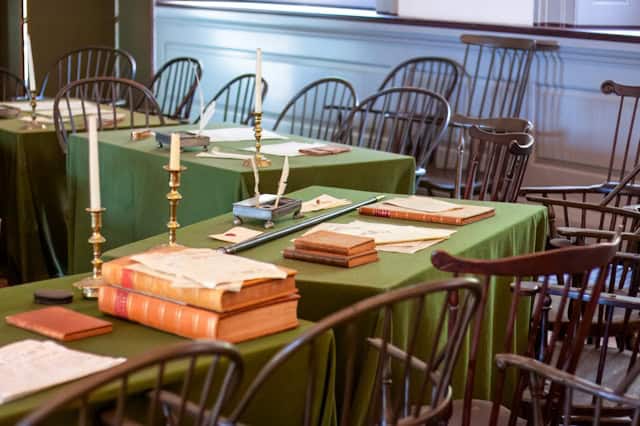
Historic Independence Hall
The Civil War Boundary
The Mason-Dixon Line runs along Pennsylvania’s southern border. It was surveyed between 1763 and 1767 to settle a boundary dispute between Pennsylvania and Maryland, but it became the symbolic dividing line between slave states and free states before the Civil War. Pennsylvania’s Emancipation Act of 1781 set a schedule for gradual abolition. Route 1 crosses the Mason-Dixon Line at West Nottingham Township — the first thing you do when you enter the state from Maryland.
The Battle of Gettysburg, fought July 1-3, 1863, was the northernmost major engagement of the war and the turning point of Lee’s second invasion of the North. Gettysburg is 60 miles west of Route 1, but its weight hangs over all of Pennsylvania’s southern tier. Lincoln gave the Gettysburg Address on November 19, 1863, redefining the war’s purpose in 272 words.
Steel, Coal, and Industrial Pennsylvania
The industrial Pennsylvania that most people picture — steel mills, coal mines, company towns — is not Route 1 country. It’s Pittsburgh and the Mon Valley, the anthracite regions around Scranton and Wilkes-Barre, the steel works of Bethlehem. Pittsburgh produced roughly a third of the national steel output by the 1920s. Andrew Carnegie built his first mills there in 1873 and sold the Carnegie Steel Corporation to J.P. Morgan in 1901 for $480 million.
Edwin Drake drilled the world’s first successful commercial oil well at Titusville in 1859 — 400 miles northwest of Route 1. The coal that powered the industrial revolution came from Northeastern Pennsylvania, not the southeastern corridor. Route 1 runs through a Pennsylvania that built its wealth on agriculture, commerce, and colonial trade rather than extraction.
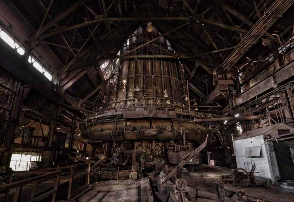
Abandoned steel mill, Mon Valley PA
What to See on Route 1 in Pennsylvania
Longwood Gardens, Kennett Square
Route 1 passes directly in front of Longwood Gardens. Pierre du Pont acquired the property in 1906 and spent 30 years building one of the great pleasure gardens of the American Gilded Age: 1,083 acres of cultivated gardens, meadows, and forests with 4.5 acres of greenhouse space. The fountain shows, designed by du Pont himself and installed beginning in 1930, are still the main event — the Main Fountain Garden can shoot water 130 feet high, synchronized to music and lights in the evening. Kennett Square produces more than half of all mushrooms grown in the United States, which is a weirder distinction than it sounds once you drive through and smell the farms.
Brandywine Battlefield, Chadds Ford
The Battle of Brandywine Creek on September 11, 1777 was the largest engagement of the Revolution by troop numbers, with roughly 30,000 men engaged. Washington lost. The British took Philadelphia eleven days later. The battlefield park in Chadds Ford preserves the Gideon Gilpin House, which served as Washington’s headquarters, and the Benjamin Ring House used by Lafayette. The Brandywine River Museum of Art sits adjacent to the battlefield, housing the largest collection of Wyeth family paintings in existence — three generations of Wyeths who lived and worked in this valley.
Philadelphia on Route 1
Route 1 enters Philadelphia as Baltimore Pike and runs into the city’s grid. Independence Hall is where the Declaration of Independence and the Constitution were both signed — the same building, at Fifth and Chestnut, open daily as part of the Independence National Historical Park. The Liberty Bell sits in a pavilion across the street. Reading Terminal Market, three blocks away, has operated continuously since 1892 and still has Amish vendors selling scrapple, soft pretzels, and shoofly pie alongside Vietnamese banh mi and Thai food. The Italian Market on Ninth Street in South Philadelphia has been there since the 1880s.
Philadelphia’s neighborhoods reflect layered immigration: colonial-era Society Hill, the African American cultural institutions of North Philadelphia, the working-class Italian enclave of South Philly, the gentrified waterfront of Fishtown and Northern Liberties. The city proper holds 1.5 million people; the metro area is over 6 million.
Downtown Scranton, PA
Washington Crossing and the Bucks County Stretch
North of Philadelphia, Route 1 runs through Bucks County along the Delaware River. Washington Crossing Historic Park marks the spot where Washington led 2,400 men across the Delaware River on the night of December 25-26, 1776, in a snowstorm, to attack the Hessian garrison at Trenton. The crossing is reenacted every Christmas Day at 11 AM. The Thompson-Neely House at the park served as a field hospital during the campaign and still stands on the grounds. Bowman’s Hill Tower, built in 1931 to mark one of Washington’s lookout points, gives a wide view of the river valley.
Route 1 exits Pennsylvania at Morrisville, crossing into Trenton, New Jersey on the Calhoun Street Bridge. Morrisville sits directly across the river from the site of the Trenton battle, making it the end point of one of the Revolution’s decisive winter campaigns.
Pennsylvania Food Along Route 1
Pennsylvania Dutch Traditions
Scrapple is the Pennsylvania Dutch breakfast meat that divides rooms. It starts with pork scraps and offal, bound with cornmeal and buckwheat flour, spiced with sage, marjoram, and thyme, formed into loaves, and pan-fried until the outside is crunchy and the inside is creamy. The Pennsylvania Dutch, German-speaking immigrants from the Rhineland who settled in Lancaster, Berks, and Chester counties beginning in the 1680s, invented it as a way to use every part of the pig. It predates the highway by 250 years and remains the most distinctly Pennsylvanian food you can eat.
Shoofly pie is a molasses crumb cake baked in a pie crust, a Mennonite and Amish staple that became popular in the post-Civil War period when cast-iron stoves made pie crust feasible for home cooks. Traditionally served with coffee for breakfast, not as a dessert. The Amish vendors at Reading Terminal Market sell both.
Philadelphia Classics
The cheesesteak debate has two sides: Pat’s King of Steaks, which claims to have invented the sandwich in 1930, and Geno’s, which opened across the street in 1966 to compete directly. Both operate 24 hours at the corner of Ninth and Passyunk in South Philadelphia. The question of whether you get Whiz or provolone is a loyalty test. Reading Terminal Market has Amish-run DiNic’s, which serves a roast pork sandwich that many people in Philadelphia consider the better sandwich, though they’ll say it quietly. Water ice, not Italian ice, is the local term. John’s Water Ice on Christian Street has been serving it since 1945.
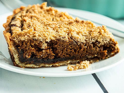
Shoofly pie is a traditional PA dessert.
Pennsylvania’s Cultural Identity
Language and Dialect
Pennsylvania has five distinct regional dialects. Philadelphia and Pittsburgh get the attention, but Erie, the Pennsylvania Dutch Country, and the anthracite coal region each maintain their own. Philadelphia’s dialect avoids the “th” sound, swallows the L in words like “Philly” itself, and produces “wooder” instead of “water.” Pittsburgh gives you “dahntahn” for downtown and “yinz” as the second-person plural. Pittsburghers who use the dialect are called Yinzers. The Pittsburgh dialect absorbed loanwords from Scots-Irish, Polish, Ukrainian, and Croatian immigrants who came to work the mills — the working-class heritage is baked into the language.
Pennsylvania Dutch Heritage
The Pennsylvania Germans arrived beginning in 1683, when Francis Daniel Pastorius led the first group to Philadelphia and founded Germantown. Most early arrivals were Mennonites, Amish, Dunkers, and Moravians fleeing religious persecution. After 1727, the immigrants shifted toward Lutheran and Reformed church members. By the Revolution they numbered 100,000, over a third of Pennsylvania’s population. Their farming transformed the interior counties into productive agricultural land. Lancaster County, the center of Pennsylvania Dutch country, remains one of the most productive non-irrigated agricultural counties in the United States.
The Old Order Amish, the most conservative branch, still farm with horses, travel by buggy, and reject electricity. Lancaster County has the largest Amish population in the world. Their presence 50 miles west of Philadelphia is one of Pennsylvania’s more striking contradictions.
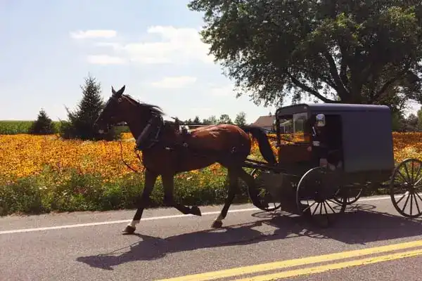
Amish buggy on a rural Lancaster County road
Arts and Architecture
The Wyeth family painted the Brandywine Valley for three generations. N.C. Wyeth, illustrator and painter, moved to Chadds Ford in 1902 and raised his children there. His son Andrew Wyeth produced “Christina’s World” in 1948, now at MoMA. Andrew’s son Jamie continues the family tradition in the same landscape. The Brandywine River Museum of Art holds the primary collection and sits on the Route 1 corridor.
Frank Lloyd Wright’s Fallingwater, built over a waterfall in Fayette County in 1939, is 200 miles west of Route 1 but remains the state’s most-visited architectural site. Closer to the highway, Independence Hall in Philadelphia is one of the finest examples of Georgian civic architecture in America, completed in 1753. Pittsburgh’s Cathedral of Learning at the University of Pittsburgh is a 42-story Gothic Revival tower, the tallest educational building in the Western Hemisphere, built between 1926 and 1937.
Off-Beat Pennsylvania Worth the Detour
Oil Creek State Park, Titusville
Oil Creek State Park occupies the valley where Edwin Drake drilled the world’s first successful commercial oil well in 1859. The Drake Well Museum on the park grounds houses the original drilling equipment and documents the 19th-century oil rush that made northwestern Pennsylvania briefly the most important energy region in the world. The park is 350 miles from Route 1, but the history it holds is foundational to understanding how Pennsylvania accumulated its industrial wealth.
Trundle Manor, Swissvale
Trundle Manor in Swissvale, a few miles from Pittsburgh, has been accumulating antique taxidermy, out-of-use medical devices, coffins, Steampunk metalwork, and other curiosities since 1910. Self-guided tours run through rooms where the collection has taken over every surface. It is the kind of place that exists because one person collected obsessively for decades and then opened the doors. There is nothing else like it in the state.
Columcille Megalith Park, Bangor
Columcille is a Celtic megalith park in the Appalachian mountains of Northampton County, founded in 1975 and inspired by the Isle of Iona off Scotland. Standing stones, stone circles, and carved Celtic crosses occupy 17 acres of forested hillside. It’s free to visit, genuinely quiet, and the kind of place that requires no framing. You either find a field of standing stones in the Pennsylvania mountains interesting or you don’t.
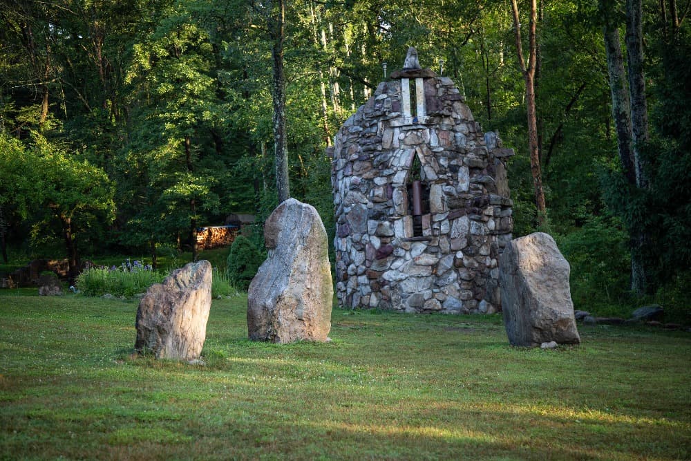
Columcille Megalith Park
Bicycle Heaven, Pittsburgh
Bicycle Heaven in Pittsburgh is the largest bicycle museum in the world, with over 3,000 bikes on display including celebrity-owned and one-of-a-kind designs. The collection fills a building so completely that bikes hang from the ceiling and stack in columns. It functions as both a museum and a shop, and the owner has been collecting for decades. The Guinness certification is on the wall.
Pennsylvania Today: Cities and Economy
Philadelphia
Philadelphia’s 1.5 million city residents and 6-million-person metro make it the sixth-largest metro in the United States. The city never fully collapsed the way Detroit or Cleveland did. Its anchor institutions — Penn, Drexel, Jefferson Health, the hospital systems, the port — kept enough economic activity to survive deindustrialization. The neighborhoods around Temple University’s campus in North Philadelphia are still struggling. The neighborhoods of Fishtown and East Passyunk in South Philadelphia have been gentrifying for fifteen years. The tension between those two realities is the current Philadelphia story.
Pittsburgh
Pittsburgh has no steel mills within its city limits. US Steel, founded here by J.P. Morgan’s 1901 acquisition of Carnegie’s company for $480 million, still has its headquarters on Grant Street. The mills are gone; the company remains. Pittsburgh’s post-steel economy runs on healthcare, higher education (Carnegie Mellon and the University of Pittsburgh together employ over 30,000 people), and technology. The city hosted the 2009 G-20 summit specifically because the Obama administration wanted to showcase successful post-industrial transition.
Secondary Cities
Scranton, Wilkes-Barre, Allentown, Bethlehem, Reading, Erie — each built its identity around a single industry that declined. Anthracite coal in the northeast, Bethlehem Steel in the Lehigh Valley, textiles in Reading. Bethlehem Steel’s main plant closed in 1995; the site is now the Sands Casino and the National Museum of Industrial History. Jim Thorpe, formerly Mauch Chunk, renamed itself after the athlete in 1954 in a bid to attract tourism and revive the economy. It worked, eventually. The town now draws hikers and mountain bikers to the Lehigh Gorge.
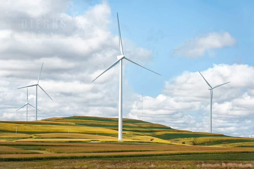
PA is investing into renewable energy sources to meet modern energy demands
Pennsylvania as a Swing State
Pennsylvania has voted for the winning presidential candidate in 83% of elections since 1824. It backed Republicans from 1860 to 1932 (except 1912, when the Republican vote split between Taft and Roosevelt and the state backed Roosevelt), then voted Democratic through most of the New Deal era. It leaned Democratic from the 1990s through 2012, flipped to Trump in 2016, and has been a genuine 50-50 battleground since.
The political map is a red “T”: rural central and western Pennsylvania votes Republican by large margins; Philadelphia and Pittsburgh vote Democratic by larger margins. The collar counties around Philadelphia and the Pittsburgh suburbs are where statewide elections are decided. Southwestern Pennsylvania, once reliably Democratic coal and steel country, has shifted dramatically toward Republicans since 2004 — counties that voted for Kerry by double digits in 2004 backed Trump by 60% in 2016. The Lehigh Valley and Chester County, meanwhile, have moved the other direction.
Share your Pennsylvania route 1 memory
Do you have a story you would like to share? We want to hear it!
Create a View to tell a unique story about a specific place
Want to see what others wrote about Pennsylvania?
Our Travel map has over 1400 posts from users like you
We have 2 types of content at Route1views:
- View: A unique experience at a single location
- Trip: A collection of experiences at different places, connected through a ‘road trip’
- Most first-time posters choose to make a View
A note about Route 1 Views
We are a user-driven social media site for celebrating and sharing stories along historic Route 1 USA. Using our platform is FREE forever and we don’t play any tricks. We don’t share your data or spam you with emails. We are all about sharing!

The Keystone State
Pennsylvania got its nickname from its central position among the original thirteen colonies, the way a keystone holds an arch together. The description still fits. The state sits at the geographic and political middle of the East Coast, neither Southern nor New England, neither fully industrial nor agricultural. Philadelphia anchors the Route 1 corridor — 100 miles of colonial history, Revolutionary War ground, and suburban sprawl between the Mason-Dixon Line and the Delaware River. The rest of Pennsylvania, from the anthracite hills to the Ohio border, is a different country that happens to share a state government.
The Route 1 Road Trip Coloring Book
36 pages · 13 states · a color-as-you-drive map. Free — print it at home.
36 pages · no email required · print at home
Want a peek inside first? See everything →It's yours — enjoy! 🖍️
No email, no strings. By the way — want the occasional Route 1 story and first dibs on the next freebie? Totally optional.
You're in — thanks! 🖍️
 Continue with Google